
Citation: Devereux, E.J.,(2023), “Focus on Ireland’s Natural Heritage: The Copper Coast Geopark”, EcoFoodDev, https://www.ecofooddev.com/focus-on-irelands-natural-heritage-the-copper-coast-geopark/(opens in a new tab)
Featured image: Trá na mBó beach, photo by author.
Introduction
This is the first post in a series focussing on distinct, unique, and magnificent features of Irish biodiversity, including our breathtaking and exceptional designated sites. The temptation when studying the natural world is to focus on far-flung places, such as cloud forests in South America, and jungles in Borneo. However, I look closer to home, and specifically closer to my own home. Having emigrated from Ireland and recently returned after over 10 years living overseas, I find I possess a fresh, renewed enthusiasm for not only the exquisite natural beauty of Ireland, but also the great strides that have been taken in appreciating our natural heritage at both national and local level. The Copper Coast is an area of Ireland that I have known since childhood. It is where I spent every summer (as more than a one-hour drive for our family vacations was out of the question completely). I built sandcastles on Clonea Strand and collected stray golf balls with my cousins on Gold Coast beach, for later clandestine use in the driving range. I was unaware that the area was recognised as a Global Geopark in 2004, and realising that the Copper Coast was a recognised, designated UNESCO Geopark was mind-blowing, and one worth visiting again. Here I take you on a drive along the coast of County Waterford.
The Copper Coast: Start at Stradbally
The Copper Coast Geopark is located on Ireland’s southeast coast, in Co. Waterford straddling the coast between Dungarvan and Tramore. Etched into the cliffs and outcrops enclosing stunning, secret beaches can be seen 460 million years of geological heritage, with a glacial outwash plain inland containing a variety of spectacular environments and habitats. Details can be found at https://en.unesco.org/global-geoparks/copper-coast.
I started my journey of the 25km coastline at Stradbally Cove, close to Dungarvan (Dungarvan Bay being a Ramsar designated wetland). Already on the approach to the village I was struck by the beauty of the place- rows of traditional thatch cottages in pristine condition, and a deciduous woodland rolling right down to the sea, so much so that you would have no idea there was a beach. The village is an attractive the focus, with the cove being the village’s little hidden secret. My first thought was that, if ‘beauty’ forms part of the definition of natural heritage value, which we know it does, then objectively Stradbally ticks this box both from a cultural and a geological perspective. Luckily, those living there feel the same, having active Tidy Towns groups.

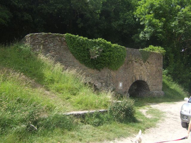
Geopark signs direct you to several features in the area, from medieval churches, to the beach. Upon arriving at the cove, information boards explain the geological history of the place, teaching the reader to spot the different volcanic and sedimentary rocks and tectonic events such as extreme shifting and earthquakes. It is also immediately noticeable that the park weaves the geological history with human-environment interactions. At Stradbally Cove your attention is drawn to the lime kilns, where quicklime was produced through the superheating of limestone that was then used primarily as fertiliser. Historical OS maps show lime kilns (LK on the map) dotted all around the Irish landscape, a common feature now gone.

The biodiversity of flora and fauna are also highlighted via information boards. It was clear from the outset that the Copper Coast is being presented as a museum to both geological history and human action on the landscape through time. Extensive copper quarrying and mining in the area is repeatedly highlighted throughout the park- and is of course enshrined in the name.


Ballydowane Beach
Next, I visited Ballydowane Beach. The geology here is entirely striking. The signage at the parking area immediately draws your attention to the 18th century lead mine that operated here, once again linking the geological and human history of the place. Here, the expanse of geological time is clearly traversed, linking the information boards to points on the cliffs, reflecting the chronology of the volcanic and glacial activity along this beach. It struck me that this area was UNESCO worthy from a learning perspective alone. The volcanic andesite here can be clearly distinguished from the Devonian sandstones and conglomerates, and how these layers formed is clearly explained. Ventilation shafts from the mining were also highlighted here.


Trá na mBó, Fenor Bog, Miners Cottages
There are numerous other beautiful beaches along the coast, such as Trá na mBó near Bunmahon, and the oft-photographed Kilfarrasy Strand.

But other features of the park include human archaeological history, from Dolmens to vernacular gravestones (such as the folk grave art as Reisk Medieval Church), Tankardstown Engine House, and areas of biotic diversity. Bunmahon houses the visitor centre, located in a beautiful medieval church that was disused and has been resurrected to be home to a small museum, information centre, shop, café, and library- with numerous local employees and volunteers working there, underlining the local sustainability of the project. What I also found very striking in Bunmahon were the miners’ cottages. Up to this point it was clear that mining was a feature of the area, and information boards detailed the wealthy men who commission the mines. But the plight of the miners was overlooked, as it often is. However, this almost seemed purposeful, as in Bunmahon the facades of the houses are quietly preserved in the town walls, an almost fitting and delicate tribute to people who did such dangerous work in the dark depths of mines beneath the sea.

Next along the journey was Fenor Bog, a beautifully maintained acidic peat fen, formed within the last 10,000 years (Holocene) in hollows formed by Quaternary glacial action. As such, it is a bog that is still forming, and it displays a wealth of wetland plants such as sedges, mosses and bog pond weeds, and a large diversity of insects and butterflies. It is tucked next to a church which itself features beautiful wooden carvings. This is a good example of how the geopark protects and displays non-geological, biological areas, and it seems to me even the process of peat formation is part of what is being protected here.


The conservation element of the Geopark designation is particularly evident at Fenor Bog, where signage details the sensitivity of bog flora and fauna to environmental change and reflects on the harvesting of peat bogs for turf.
The website https://coppercoastgeopark.com/ contains a wealth of information on the Geopark, including walking and cycling trails, activities for children, and 3D tours. The archaeology, geology, and built heritage of the area is detailed, and information of the flora and fauna of the area is included. I did expect to see a section on conservation and sustainability which was lacking.
Below are a few images of other sites I managed to fit in to the visit, and there are so many more that I haven’t yet seen. It is an extensive amount of area to cover, the geology park, several dolmens, and more, it truly is an outstanding area with an abundance of natural and cultural heritage, which I certainly had not appreciated before following the Geopark trail, and certainly worthy of World Heritage designation.

